A contractor breaking ground on the Castletown River floodplain hit a buried channel of loose alluvium at 14 metres. The borehole log showed one profile, but the ground behaviour next to it was completely different. Seismic tomography fills that gap. The refraction method maps the top of rock and identifies fractured zones beneath overburden, while reflection imaging resolves deeper strata where the velocity contrast is low. In Dundalk, where glacial tills overlie Silurian greywacke and the water table sits shallow, combining both techniques prevents surprises during piling or excavation. A CPT test can verify the soft layers, and when the project demands continuous stiffness profiles we also run MASW to capture shear-wave velocity down to 30 metres.
When till thickness varies from 3 to 20 metres across a single site, only a continuous seismic profile reveals the true bedrock surface.
Service characteristics in Dundalk
Critical ground factors in Dundalk
The low-lying areas south of Dundalk towards the Fane River hide buried valleys filled with soft estuarine silts. These channels are invisible from the surface and can be missed entirely by a grid of boreholes spaced 30 metres apart. A seismic refraction survey detects them as a sharp velocity drop below the till — a signature that stands out clearly against the 3,500 m/s bedrock. Skipping the geophysical step means assuming homogeneous ground, and that assumption fails often in this part of County Louth. The reflection method adds a second safety net: it images the internal bedding of the glacial sequence, flagging sand lenses that carry groundwater under pressure. When the client needs a rockhead contour map with ±0.5 m accuracy for foundation design, the field crew switches to a tighter geophone array and runs reciprocal travel-time checks on every spread.
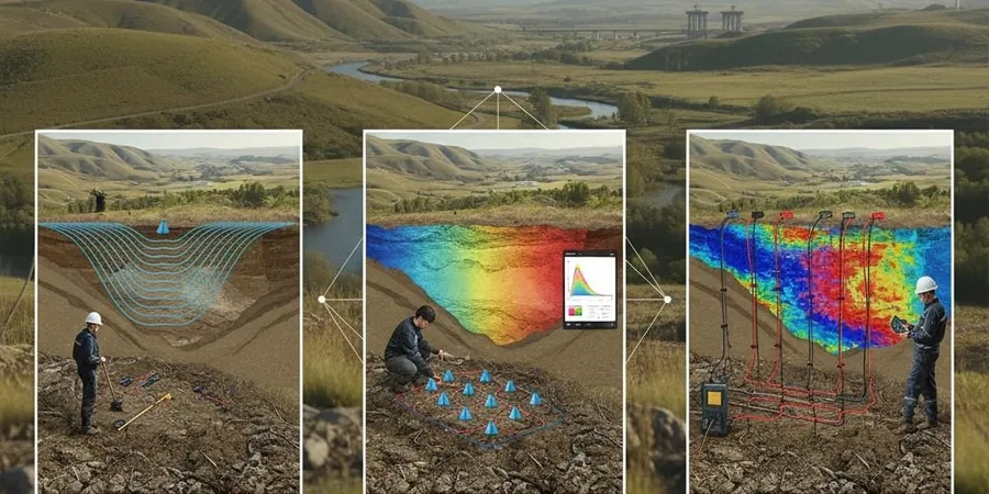
Our services
The seismic survey programme in Dundalk is tailored to the ground conditions and the engineering question. Each method is selected based on target depth and required resolution.
P-wave Seismic Refraction
24- or 48-channel profiling for bedrock depth, rippability, and fault detection. Inversion with delay-time and tomography algorithms.
High-resolution Seismic Reflection
CMP reflection profiling for targets deeper than 50 m. Suitable for imaging buried valleys and deep stratigraphic traps beneath the till.
Downhole and Crosshole Surveys
Borehole seismic for interval velocity and elastic moduli. Source in one borehole, receivers in adjacent holes.
Surface Wave Analysis Integration
Combined refraction and MASW acquisition on the same spread to deliver both P-wave and S-wave velocity models for site classification.
Frequently asked questions
What ground conditions in Dundalk suit seismic refraction best?
Refraction works well where the bedrock velocity is higher than the overburden — a condition met across most of Dundalk, where glacial till and soft clays overlie Silurian greywacke. The velocity contrast is typically strong enough to produce clear first arrivals.
How much does a seismic refraction survey cost in Dundalk?
A typical refraction survey in the Dundalk area ranges from €2,130 to €5,440, depending on the line length, spread configuration, and whether reflection processing is added. Each quote is based on the specific target depth and site access conditions.
How long does fieldwork take for a seismic survey?
A single 115-metre refraction line with 24 geophones can be acquired in half a day. Larger grids with multiple lines or combined refraction and reflection acquisition may require two to three days on site, plus processing time.